Join devRant
Do all the things like
++ or -- rants, post your own rants, comment on others' rants and build your customized dev avatar
Sign Up
Pipeless API

From the creators of devRant, Pipeless lets you power real-time personalized recommendations and activity feeds using a simple API
Learn More
Search - "what about line 1-16?"
-
Everyone and their dog is making a game, so why can't I?
1. open world (check)
2. taking inspiration from metro and fallout (check)
3. on a map roughly the size of the u.s. (check)
So I thought what I'd do is pretend to be one of those deaf mutes. While also pretending to be a programmer. Sometimes you make believe
so hard that it comes true apparently.
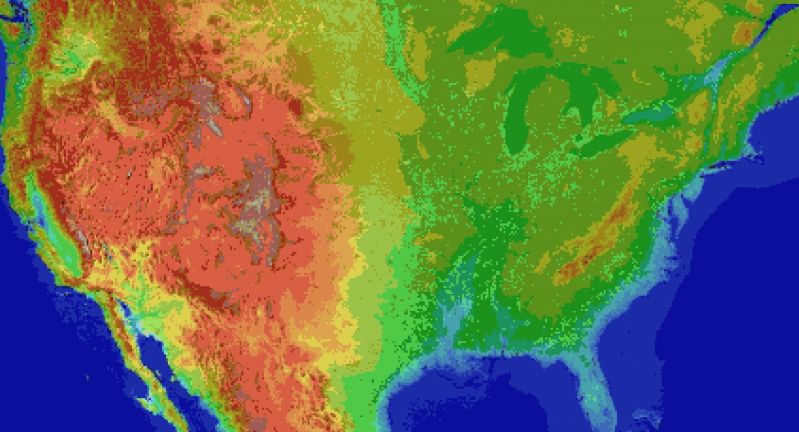
For the main map I thought I'd automate laying down the base map before hand tweaking it. It's been a bit of a slog. Roughly 1 pixel per mile. (okay, 1973 by 1067). The u.s. is 3.1 million miles, this would work out to 2.1 million miles instead. Eh.
Wrote the script to filter out all the ocean pixels, based on the elevation map, and output the difference. Still had to edit around the shoreline but it sped things up a lot. Just attached the elevation map, because the actual one is an ugly cluster of death magenta to represent the ocean.
Consequence of filtering is, the shoreline is messy and not entirely representative of the u.s.
The preprocessing step also added a lot of in-land 'lakes' that don't exist in some areas, like death valley. Already expected that.
But the plus side is I now have map layers for both elevation and ecology biomes. Aligning them close enough so that the heightmap wasn't displaced, and didn't cut off the shoreline in the ecology layer (at export), was a royal pain, and as super finicky. But thankfully thats done.
Next step is to go through the ecology map, copy each key color, and write down the biome id, courtesy of the 2017 ecoregions project.
From there, I write down the primary landscape features (water, plants, trees, terrain roughness, etc), anything easy to convey.
Main thing I'm interested in is tree types, because those, as tiles, convey a lot more information about the hex terrain than anything else.
Once the biomes are marked, and the tree types are written, the next step is to assign a tile to each tree type, and each density level of mountains (flat, hills, mountains, snowcapped peaks, etc).
The reference ids, colors, and numbers on the map will simplify the process.
After that, I'll write an exporter with python, and dump to csv or another format.
Next steps are laying out the instances in the level editor, that'll act as the tiles in question.
Theres a few naive approaches:
Spawn all the relevant instances at startup, and load the corresponding tiles.
Or setup chunks of instances, enough to cover the camera, and a buffer surrounding the camera. As the camera moves, reconfigure the instances to match the streamed in tile data.
Instances here make sense, because if theres any simulation going on (and I'd like there to be), they can detect in event code, when they are in the invisible buffer around the camera but not yet visible, and be activated by the camera, or deactive themselves after leaving the camera and buffer's area.
The alternative is to let a global controller stream the data in, as a series of tile IDs, corresponding to the various tile sprites, and code global interaction like tile picking into a single event, which seems unwieldy and not at all manageable. I can see it turning into a giant switch case already.
So instances it is.
Actually, if I do 16^2 pixel chunks, it only works out to 124x68 chunks in all. A few thousand, mostly inactive chunks is pretty trivial, and simplifies spawning and serializing/deserializing.
All of this doesn't account for
* putting lakes back in that aren't present
* lots of islands and parts of shores that would typically have bays and parts that jut out, need reworked.
* great lakes need refinement and corrections
* elevation key map too blocky. Need a higher resolution one while reducing color count
This can be solved by introducing some noise into the elevations, varying say, within one standard div.
* mountains will still require refinement to individual state geography. Thats for later on
* shoreline is too smooth, and needs to be less straight-line and less blocky. less corners.
* rivers need added, not just large ones but smaller ones too
* available tree assets need to be matched, as best and fully as possible, to types of trees represented in biome data, so that even if I don't have an exact match, I can still place *something* thats native or looks close enough to what you would expect in a given biome.
Ponderosa pines vs white pines for example.
This also doesn't account for 1. major and minor roads, 2. artificial and natural attractions, 3. other major features people in any given state are familiar with. 4. named places, 5. infrastructure, 6. cities and buildings and towns.
Also I'm pretty sure I cut off part of florida.
Woops, sorry everglades.
Guess I'll just make it a death-zone from nuclear fallout.
Take that gators! 5
5 -
2023 is the year where i am making a lot of bold choices and immediately regretting them.anxiety is at peak, and my past good deeds are hopefully saving me from getting into a real danger, but i am not aure for how long.
1. (technically a 2022 choice/blunder but impacted in2023 ) : we go for a yearly trip to a religious place in dec last- jan 1st week. i booked a flight instead of trains which we usually take, and are cheaper but take 16 extra hours. result? flight got cancelled, wr booked another more expensive flight for the next day, i got extremely sick and being stuck on a totally strange place on the 2nd day of 2023 was a nightmarish experience for mom ( the airport was 400km away from the village we go and its a totally new city for us)
2. resigned from my job on the pretext that they will be eventually asking us to work from head office(which is in a far city). they are yet to mandate it, and are rather opening a new office in my own city , so i would have to probably report from my city's office if i had stayed. super regrets, as that company gave very less work and lots of perks. this was the first job in which i was able to disconnect from work to understand real world and care for my people.
3. when i quitted the above job, i had no offer from any company after applying to 200+ job openings. one large MNC, with which i interviewed in last November 22 had given me an offer back then which i had rejected due to being a low offer , and having shitty popularity and policies ( they are known for being a toxic, mind numbing workplace and have a 3 month notice period) . but due to panice caused by work-from-head-office rumour, i asked them to give me offer again. the did and now i regret joining them and their shitty policies
4. latest in line : i have been fantasizing a trekk/hiking trip but neither do i have any siblings to go on with, nor my friends got time or interest in it.
i saw a few pages on Instagram, they take groups of people to mountains and offroad places via buses so booked a seat for me. a freaking solo trip! lots of exciting happy thoughts when i gave them my money, but as i approach the date of departure , i am freaking the fuck out.
they are not communicating with me . i don't know what to pack, whom to rely upon , whether they will have single traveller like me or if they will have couples and i will be left out to rot and struggle on my own, will it he safe or not,... to many questions and they aren't satisfying me with any of their answers.
i know my parents are in guilt about me resigning from my jobas they didn't wanted me to work from head office and they are shit scared too, but still allowing. however, i am even more double shit scared
i hope this doesn't turn into my last worst decision.6 -
My favorite xkcd quotes (order is not significant )
1. _*It's the world's tiniest open-source violin.*_
2. ...too honest. Scale it back.
3. I'd like to bestow upon you the first annual AWARD of EXCELLENCE in BEING VERY SMART. May you continue to grace our internet with your wisdom.
4. wait, what?
5. Yeah, uh ... I accidentally took the Fourier transform of my cat ...
6. Okay, we _suck_ at this.
7. You either need more medication or less. Not sure which.
8. I THINK EVERYONE INVOLVED HERE IS CUTE
9. World's Greatest Daughter
10. People who open bananas for the other end
11. Just for the sake of the argument, we should get a boat! You can invite the Devil, too, if you want.
12. This explain a lot.
13. My bag is 90% backup batteries.
14. Well- will you be my "it's complicated" on facebook?
15. Oh God. Gotta get out. The window.
16. Sweet! I finally got my subduction license!
17. I'll tell you later - you wouldn't appreciate the punchline over this 12kbps cell phone codec.
18. RON PAUL evolves into TRON PAUL
19. Just talk to them like a f***ing human being
20. In ordering #5, self-driving cars will happily drive you around, but if you tell them to drive to a car dealership, they just lock the doors and politely ask how long humans take to starve to death.
21. I eat my body weight in food every 31 days. That's slightly faster than the human average.
22. Nice try, Mike. Get out of the well.
23. Apollo retroreflectors
24. Can't see space vampires
25. My class on screenshots was a big hit, although for some reason I only ever sold one copy of the digital textbook.
26. WHAT.
27. Introducing The xkcd Phone 6, VIII, 10, X, 26, and 1876. We didn't start this nonconsecutive version number war, but we will not lose it.
28. My morality has evaporated over the harsh UV light.
29. Come on. Somewhere at the edge of the bell curve is the girl for me.
30. P.P.S. I can kill you with my brain.
31. Time to accelerate this giant machine up to terrifying speeds and steer it using my hands, which I am allowed to do because I took a 20-minute test in high school!
32. My normal approach is useless here
33. Wake up, sheeple!
34. Sir- strategic command has send us a lunch order.
35. Yeah, but first I'm gonna go comatose for a few hours, hallucinate vividly, and maybe suffer amnesia about the whole experience.
36. HOLY S***. Guys- people are complicated!
37. OH GOD- SPIDERS
38. Perhaps you need a crash course in taking hints. Here's your first lesson: We're not actually walking somewhere together; I'm trying to leave this conversation and you're following me.
39. How did the pole vaulters get up to our balcony?
40. Friggin' Python
41. I am the goddamn *Michael Jordan* of blurring the line between metaphor and reality. [tosses a basketball]

